USA Surveying & Engineering, LLC (J. Keith Maxwell, PE, PLS)
We have a network of highly competent land surveyors throughout Indiana to complete ALTA Surveys for your project. Call Keith at 800-798-9540 and let him know which city or county the project is in. 
USA Surveying & Engineering, LLC is owned by J. Keith Maxwell. He formed the network of Surveyors in the state and manages this website. Keith holds a Professional Land Surveyors license and Professional Engineers license in the state of Alabama. He has over 30 years experience with all types of commercial land surveying and commercial land development projects. Over the last 28 years he has completed numerous ALTA Surveys.
Call 800-798-9540 to speak with Keith about an ALTA Survey in Indiana. Keith works with a network of licensed Land Surveyor Associates all around the state. We will select the closest one to your location, AND the best for the job. Keith can also guide you to Civil Engineering services if you need them for your project.
Maps & Resources for Indiana
- Indiana Map – see Add Layers – Reference for useful info (Parcels, PLSS, Benchmarks, etc)
- Indiana County Mapping Links – by County & Theme
- Stats Indiana – Indiana’s Public Data Utility
- FEMA Flood Maps Site
- USGS Quadrangle Maps
- 2021 ALTA Land Survey Standards (PDF format)
- 2021 ALTA Table A only (PDF format)
Guaranteed Results
Our Indiana surveyors take customer satisfaction seriously. We want to know your requirements and goals for the job. Then we’ll work to complete the project to meet your approval. If you have questions about the process or the survey, we have the answers. We’re eager to help you. We will listen to your questions, and then do our best to resolve them when you call us. We will also help to develop the scope of work for what needs to be done on your project and do our best to meet those expectations.
Areas We Serve in Indiana
We have a network of highly competent land surveyors throughout Indiana to complete ALTA Surveys for your project. Call Keith at 800-798-9540 and let him know which city or county the project is in.
Central Indiana
- Anderson, IN
- Bloomington, IN
- Carmel, IN
- Greenwood, IN
- Lafayette, IN
- Muncie, IN
- Noblesville, IN
- Westfield, IN
Northern Indiana
Southern Indiana
Eastern Indiana
ALTA Land Title Survey
An ALTA Land Title Survey is completed based on the “Minimum Standard Detail Requirements and Accuracy Standards For ALTA/NSPS Land Title Surveys.” This ALTA survey standards document was developed and is revised on a regular basis by a combination of Title industry (the American Land Title Association) and Surveying industry (the National Society of Professional Surveyors) professionals. The latest version of this document is the 2021 revision.
ALTA Survey Costs
Since ALTA Surveys take more time and effort, these surveys typically cost more than a survey done according to a particular state standard. I should point out that if the state standard is more restrictive on a certain point, then the most restrictive standard rules.
I see ALTA surveys priced from 50% to 250% more than a comparable boundary survey. This depends on the items checked in “Table A – Optional Survey Responsibilities and Specifications.” This table adds additional or specific tasks to the surveyor’s scope of work. One item that is usually included with most all ALTA survey requests is Item #1, monuments placed. Indiana Surveying standards include this and, in my opinion, all surveys should, but the ALTA survey leaves this optional unless the item is checked on Table A. In regard to this, one of the things I appreciate is that the client is “supposed to” not only fill out this Table A but also to furnish title documents to the surveyor BEFORE he starts the survey. In practice we rarely get the title documents until we issue the first draft of the survey. At that time the documents are sent to us and we are asked to revise the survey and show them. While this is not the way its planned, at least we have the chance to review the documents before issuing the final version of the survey.
Predicted Population Growth Across Indiana
 Overall the population of Indiana grew about 3.2% from 2010 through 2018, a little over 208,000 people. The Census experts predict that about 23,100 of those came from domestic migration, within the United States. Another almost 60,000 came from International migration. The rest came from natural increases (births minus deaths.)
With a population of 829,817, Indianapolis is the largest city in Indiana and the 12th-largest in the United States, according to the 2010 Census. Three other cities in Indiana have a population greater than 100,000: Fort Wayne (253,617), Evansville (117,429) and South Bend (101,168). Since 2000, Fishers has seen the largest population rise among the state’s 20 largest cities with an increase of 100 percent.
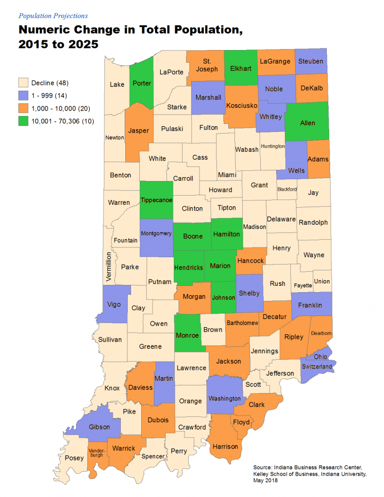
Listed from the North, the following Counties are predicted to grow from 10,000 to 70,000 people each through 2025:
- Porter – near Gary, and in the Chicago metro area, 2018 population of 169,594
- Elkhart – east of South Bend and on the Michigan border, 2018 population of 205,560
- Allen – Fort Wayne and its metro area, 2018 population of 375,351
- Tippecanoe – contains Lafayette and home to Purdue University, 2018 population of 193,048
- Boone – northwest of Indianapolis, 2018 population of 66,999
- Hamilton – northeast of Indianapolis, contains Carmel and Fishers, 2018 population of 330,086
- Hendricks – west of Indianapolis, 2018 population of 167,009
- Marion – contains City of Indianapolis & Indianapolis Motor Speedway, 2018 population of 954,670
- Johnson – south of Indianapolis, 2018 population of 156,225
- Monroe – contains City of Bloomington, 2018 population of 146,917
Summary
So, if you have a commercial parcel or a large multi-family residential complex, you should consider asking for the ALTA standards to be used. You should also probably do this if you are considering the purchase or development of a parcel outside your
state. Most of the banks will require this if you ask for a loan on this type property, but I recommend this even if the bank doesn’t require it.
If we can help you with an ALTA Survey in Indiana, please contact us at (800) 798-9540 or fill out our Table A and Contact form.
7 Advantages to Using the ALTA Survey Standards:
- Uniform Standard. The ALTA standards are a uniform nation-wide survey standard. These national standards make it easy for the title company to review the survey and write title insurance on the property, which controls the financial risk for the owners and lenders.
- Encroachments/Easements Shown. Encroachments are when a property owner violates the property rights of his neighbor by building something on, or over, the neighbor’s land. If described sufficiently, an ALTA survey should show potential encroachments and plot recorded easements on the survey drawing. Whether a potential encroachment or physical condition is an actual encroachment or not is a legal determination.
- Familiarity. Most all of the parties in any deal – lenders, attorneys, surveyors, and title professionals – are familiar with the ALTA survey standards. Working together with this same survey standard allows them to “play off the same sheet of music,” so to speak.
- Title Research. The surveyor has the advantage of having the deed research from the title commitment before issuing the final version of the survey. In other standards, this is not required.
- ALTA Table A Items. The ALTA survey standards include a list of optional items (Table A) that may be needed and ordered when the original survey is ordered. This may save money since the work is done at the same time as the boundary survey.
- Title Exceptions. Title exceptions are matters which are not covered by the title insurance policy. Two, or more, such exceptions deal with matters which may be found by an accurate survey of the property; encroachments, for example. Exceptions limit the liability of the title insurer to the insured. Completion of an ALTA survey allows the title insurer to remove those exceptions.
- Consistent Scope of Work. Usually the hardest part of any contract is determining the scope of work and how it will be completed. The ALTA survey standards provide a consistent scope of work that has been used since 1988 and is frequently reviewed and updated to conform to the latest technology and legal issues.
