An ALTA Survey is done based on the “Minimum Standard Detail Requirements and Accuracy Standards For ALTA/NSPS Land Title Surveys.” This ALTA survey standards document was developed and is revised on a regular basis by a combination of Title industry and surveying professionals. The title industry is represented by the American Land Title Association. The Surveying industry is represented by the National Society of Professional Surveyors. The latest version of this document is the 2021 revision.
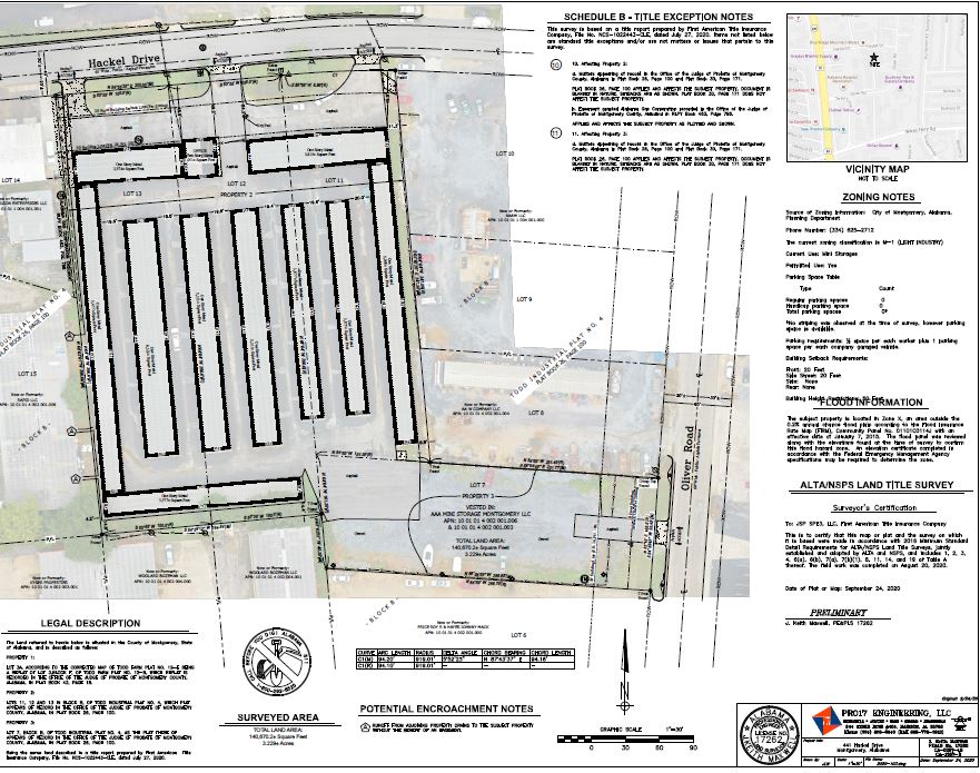
Check out a recently completed ALTA Land Survey drawing that was presented to our satisfied client.
Call (800) 798-9540 today to discuss your ALTA Survey project, or submit our online ALTA Quote Request & Table A.
Download the ALTA Standards:
- ALTA/NSPS Land Title Survey Standards, 2021 Version OR 2016 Version – PDF version (2021 Version effective February 23, 2021.)
- 2021 ALTA Table A Items List OR 2016 ALTA Table A Items List – a PDF of Table A for ordering the survey. This must be provided to the surveyor in order to get a quote.
- Here is an MS Windows .docx Version of Table A (2021 Version.)
An ALTA Land Survey is generally similar to a boundary or lot survey on a piece of property. But, the ALTA survey goes a little farther in the requirements on the land surveyor as he/she carries out the survey, both in the field and in the office.
Introduction to ALTA Survey Services
At ALTALandSurvey.com, we specialize in delivering ALTA survey services nationwide with an authority you can trust. Our team of licensed surveyors and engineers brings decades of professional land surveying and engineering experience to every project, ensuring that each ALTA/NSPS Land Title Survey meets the highest standards of accuracy and detail. We understand the critical role of ALTA surveys in commercial real estate – they are often the gold standard required by developers, real estate attorneys, and title professionals to facilitate smooth transactions and secure title insurance. Every survey we produce adheres strictly to the latest ALTA and NSPS requirements, providing you with a reliable foundation for property deals and legal due diligence . Our authoritative approach means you receive a comprehensive land survey that clearly delineates property boundaries, notes any easements or encroachments, and helps prevent future disputes, no matter where your project is located.

We take pride in our ability to tackle complex surveying projects and unique site challenges. Our firm has developed particular expertise in solar farm ALTA surveys, leveraging advanced aerial mapping technology to efficiently cover large-acreage sites with precision. By integrating high-resolution drone imagery and LiDAR scanning, we capture detailed topographic and planimetric data for even the most expansive properties . This technological edge allows us to deliver precise ALTA survey results on large-scale projects (such as utility-scale solar installations) without sacrificing speed or accuracy . Our service offerings are broad and nationwide, but we maintain meticulous attention to detail on every site feature – from boundary monuments and terrain contours to buildings and utility locations – so that nothing is overlooked in your land title survey.
Our Specialized ALTA Survey Services Include:
- Solar Farm ALTA Surveys – Comprehensive surveying for large renewable energy sites, using aerial mapping to meet ALTA standards efficiently on vast properties.
- Aerial Mapping & Drone LiDAR – Cutting-edge mapping techniques that provide high-definition orthographic images and elevation models, ensuring pinpoint accuracy for all survey data.
- Trusted Expertise – A track record built on decades of experience in land surveying and civil engineering, which translates into authoritative survey reports that professionals can rely on.
When you choose ALTALandSurvey.com as your ALTA survey partner, you gain the confidence of working with a team that understands the stakes and nuances of commercial real estate. We deliver uniform, nationally recognized ALTA surveys that simplify the closing process for multi-state transactions by providing consistent results across jurisdictions. Our commitment to quality and integrity means your survey will be completed on time, certified to ALTA/NSPS standards, and ready to support your project’s success. Whether you’re a developer securing a new site, a real estate attorney verifying property details, or a title professional underwriting a policy, our nationwide ALTA survey services give you the accurate information and peace of mind you need to proceed with certainty. Experience the difference of an ALTA survey team that combines deep expertise, innovative mapping technology, and an unwavering focus on excellence – ensuring your land title interests are protected every step of the way.
Commercial Properties Require ALTA Surveys
ALTA Title Surveys are generally used on commercial or multi-family residential sites and also when either the lender or owner is in another state. The ALTA standards are a “national standard” for surveying, intended to yield a consistent survey no matter what state the work is done. Most States have surveying standards, but they vary widely from one to the other. So, the ALTA standards are used to minimize the variation.
Call (800) 798-9540 today to discuss your ALTA Land Title Survey project,
or submit our online ALTA Quote Request & Table A.
ALTA Survey Costs
Since ALTA Surveys take more time and effort, these surveys typically cost more than a survey done according to a particular state standard. I should point out that if the state standard is more restrictive on a certain point, then the most restrictive standard rules.
I see ALTA surveys priced from 50% to 200% more than a comparable boundary survey. This depends on the items checked in “Table A – Optional Survey Responsibilities and Specifications.” This table adds additional or specific tasks to the surveyor’s scope of work.
One item that is usually included with most all survey requests is Item #1, monuments placed. Most States’ surveying standards include this and, in my opinion, all surveys should. But the ALTA survey leaves this optional unless the item is checked on Table A. There are, however, a couple of states (California and Oregon for example) that will allow the surveyor to NOT set a corner that is not found during the survey. Supposedly this saves the client money, and it does. But, the reason for that savings is that those states REQUIRE any pin that is being set to have a Record of Survey completed. This process usually adds ,500 to ,000 to the survey cost. Ouch!
Another expensive item is Table A Item 11 – Underground Utilities that are within the property boundaries. This item requires the hiring of a Private Underground Utility Location service to mark all of the underground utilities. If your parcel is a large lot, this will add to the cost significantly.
Requirements for You
One of the things I appreciate about the ALTA standard is that the client should not only fill out this Table A but also furnish the title documents to the surveyor BEFORE he starts the survey. In practice we rarely get the title documents until we issue the first draft of the survey. At that time the documents are sent to us and we are asked to revise the survey and show them. While this is not the way its planned, at least we have the chance to review the documents before issuing the final version of the survey.
So, if you have a commercial parcel or a large multi-family residential complex, you should consider asking for the ALTA standards to be used.
You should also probably do this if you are considering the purchase or development of a parcel outside your state. Most of the banks will require this if you ask for a loan on this type property, but I recommend this even if the bank doesn’t require it.
7 Advantages to Using the ALTA Survey Standards:
- Uniform Standard. The ALTA standards are a uniform nation-wide survey standard. These national standards make it easy for the title company to review the survey and write title insurance on the property, which controls the financial risk for the owners and lenders.
- Encroachments/Easements Shown. Encroachments are when a property owner violates the property rights of his neighbor by building something on, or over, the neighbor’s land. If described sufficiently, an ALTA title survey should show potential encroachments and plot recorded easements on the survey drawing. Whether a potential encroachment or physical condition is an actual encroachment or not is a legal determination.
- Familiarity. Most all of the parties in any deal – lenders, attorneys, surveyors, and title professionals – are familiar with the ALTA survey standards. Working together with this same survey standard allows them to “play off the same sheet of music,” so to speak.
- Title Research. The surveyor has the advantage of having the deed research from the title commitment before issuing the final version of the survey. In other standards, this is not required.
- ALTA Table A Items. The ALTA land title survey standards include a list of optional items (Table A) that may be needed and ordered when the original survey is ordered. This may save money since the work is done at the same time as the boundary survey.
- Title Exceptions. Title exceptions are matters which are not covered by the title insurance policy. Two, or more, such exceptions deal with matters which may be found by an accurate survey of the property; encroachments, for example. Exceptions limit the liability of the title insurer to the insured. Completion of an ALTA survey allows the title insurer to remove those exceptions.
- Consistent Scope of Work. Usually the hardest part of any contract is determining the scope of work and how it will be completed. The ALTA land title survey standards provide a consistent scope of work that has been used since 1988 and is frequently reviewed and updated to conform to the latest technology and legal issues.
Definitions
ALTA – American Land Title Association – the trade organization for Title professionals
NSPS – National Society of Professional Surveyors – trade organization for Surveyors
Survey Standards – a document that guides the surveyor in the standard of care that she should follow in carrying out a survey. These may also be referred to as Minimum Technical Standards or Standards of Practice.
ALTA Table A – This table adds additional or specific tasks to the surveyor’s scope of work as selected by the person ordering the ALTA survey.
Commercial Survey – A survey of commercial property (also called commercial real estate, investment or income property) which refers to buildings or land intended to generate a profit, either from capital gain or rental income. Examples are office buildings, restaurants, retail, hotels, multifamily, and industrial.
Multifamily Survey – A survey of Multifamily residential property (also known as multidwelling) is a classification of housing where multiple separate housing units for residential inhabitants are contained within one building or several buildings within one complex. A common form is an apartment building.
Residential Paving High Point is also a friend of this site.


