Item 5: Topographic Mapping Options
We want to review the options that you have with getting topographic mapping information for your commercial property when contracting an ALTA survey. There are three ways to get contour maps:
- Use existing mapping Data that is currently available.
- Get new mapping data from new drone photography capture missions.
- Get new mapping data from new drone LiDAR capture missions.
Existing Topographic Mapping
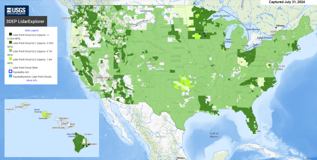
The best option for existing topographic mapping, if it’s available, is existing LiDAR data from the USGS or other local entity. This data is available in most areas of the United States. The data is in point cloud format (LAS files) which can be converted to contour maps. The quality (QL-2) is stated as being able to provide 2-foot contour interval maps, which can be interpolated to 1-foot contours.
This is a perfect solution for being able to do master land planning or lot layouts for a proposed use on your property. There will need to be additional field survey work to add more precise elevations in the areas like for new sanitary sewer lines and street roadway design.
When we use this existing available mapping, we always include taking check shots on the ground in various areas in order to field check the LiDAR data. Overall, this method is a very reasonable solution at a fairly economical price.
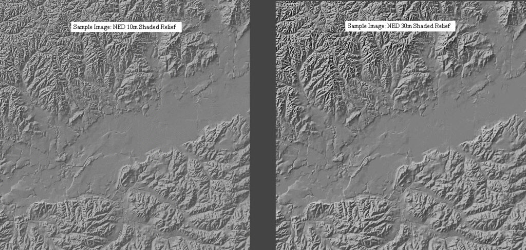
It should be noted that there are SOME areas in the US that don’t meet this QL-2 quality level. The whole US is mapped with the NED 10 (10 meter spacing) which will only produce a 1-3 meters (3-10 feet) contour map, at best.

Collecting New Photographic Image Data
This option involves flying over the property, likely with a drone, that has a high precision camera for collecting overlapping images.
In areas that do not have a lot of trees, photographic images are the best solution. These photographs can be processed to create a couple of different mapping options. The first is an orthometric photo (also called an orthophoto) which takes out the distortion from the photographs and gives you a flat map-like image of the property.
The contours are created from a process called photogrammetry. Ground shots spacing with this method is in the range of a 10-30 feet grid. This involves setting ground control points that are used in the photographic processing phase. These ground control points are set by the surveyor.
This photogrammetry process will produce a very good 1-foot contour mapping file. Contours are accurate to plus or minus half the contour interval. Spot elevation shots are accurate to within a quarter of the contour interval. Again, this isn’t the best option to use for vegetated areas.

Collecting New LiDAR Sensor Data for Topographic Mapping
For wooded property, the LiDAR sensor is needed. This allows us to get points from the ground beneath the tree canopies. LiDAR ground shot spacing is in the 1-foot grid range. Obviously this cost some more because of the added expense of the different sensor. The price has been coming down over the last few years though. Of course if you need precise elevations, this is the best option.
As an engineer, I would still say that a surveyor should take some field measurements where a sanitary sewer main is to be located before doing the design. And to ensure that the roadway design is precise, and that the earthwork grading calculations are accurate, the roads should be also surveyed conventionally.
It should be noted that even with LiDAR sensors, the ground surface in the wooded areas are not as precise as the ground surface in cleared areas. But because of the very small grid spacing again these surface models are very precise.
Accuracy Terms
NED – National Elevation Dataset – refers to NED 3 (highest resolution of approx 1-3 meters), NED 10 (10 m), NED 30 (30 m), and NED 60 (60 m). These datasets use the GeoTIFF format and the UTM or NAD 83 spatial reference. See the National Map for more information and availability. The NED is managed by the USGS.

3DEP – 3D Elevation Program – A term that includes private and public partners that fund the acquisition of elevation data. This is also managed by the USGS.
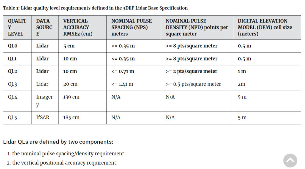
Topographic Data Quality Levels – 3DEP LiDAR Base Specifications

AI Prompt: How does the accuracy of NED 10 compare to LiDAR Quality Level 2 (QL2) data?
LiDAR Quality Level 2 (QL2) data typically has a significantly higher vertical accuracy compared to the NED 10-meter dataset. Here are some key comparisons:
- Vertical Accuracy:
- NED 10-Meter Dataset: Generally ranges from 1 to 3 meters.
- LiDAR QL2 Data: Vertical accuracy is typically around 10 centimeters (0.1 meters) or better.
- Resolution:
- NED 10-Meter Dataset: Has a spatial resolution of 10 meters, meaning the elevation data points are spaced 10 meters apart.
- LiDAR QL2 Data: Has a much finer spatial resolution, often with point spacings of around 0.7 to 1 meter or even finer, depending on the specific survey.
- Data Source:
- NED 10-Meter Dataset: Derived from various sources including photogrammetry, existing topographic maps, and some LiDAR data.
- LiDAR QL2 Data: Specifically acquired using LiDAR technology, which provides high-density point clouds and highly detailed surface models.
- Applications:
- NED 10-Meter Dataset: Suitable for regional-scale studies and applications where very high precision is not critical.
- LiDAR QL2 Data: Ideal for detailed topographic mapping, flood modeling, vegetation analysis, infrastructure planning, and other applications requiring high precision and detail.
In summary, LiDAR QL2 data provides a much higher level of vertical accuracy and resolution compared to the NED 10-meter dataset, making it preferable for applications requiring detailed and precise elevation information.
